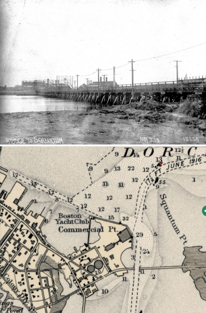
Dorchester Illustration 2521 Victory Road Bridge to Squantum
During World War I, a bridge was built from Commercial Point, Dorchester, to Squantum, Quincy, to allow workers to travel from Boston to the plant manufacturing destroyers at the Naval Air Station in Squantum.
Today we have a photo showing the bridge and a portion of a US Coast Survey chart of Boston Harbor from 1921 showing the location of the bridge across the opening of the Neponset River. The view in the photograph is from the Quincy side toward Commercial Point with its coal gas holders. The bridge first shows up in the Bromley Dorchester Atlas in 1918 and on the 1919 US Coast Survey chart, but by the 1927 Coast Survey it no longer appears. We have not seen coast surveys between 1923 and 1927, so we don’t know the exact year it was taken down. A comment found on the internet without documentation states it was taken down in 1925.
The following comes from Scientific American, May 4, 1918, p. 407
Building a Bridge in Six Weeks to Save a Half Hour
Nothing is too costly or impossible in carrying out our war program. That is the impression one gets when travelling through any section of this big country during these days of preparation and toil for the struggle across the sea.
A typical case is that of the Squantum Destroyer Plant near Boston, Mass., which is popularly known as the Victory Plant in that locality. One of the chief difficulties in locating the plant on the Quincy side of the Neponset River was the inaccessibility to Boston and the lost time and inconvenience of laborers and mechanics in getting to work.
Something had to be done–and done in a hurry.
So it was decided to run a bridge directly from the Squantum plant to the nearest point, which is known as Commercial Point, Dorchester. As time was the paramount element, the type of construction decided upon was the usual wood pile construction, and as the bridge crosses a navigable river, a draw had to be installed which was, of course, of steel. Work was started late in October, under the direction of Thomas C. Atwood, Supervising Engineer for the Bureau of Yards and Docks. The bridge was completed shortly after the middle of December, so that by Christmas all laborers to and from the plan were furnished a direct route 20 minutes from the elevated terminal in Boston, thus doing away with approximately two and a half miles of distance to be traveled and one-half hour’s time for each trip; furthermore, and this is an important consideration where workmen are concerned, the extra carfare called for by the second street railway company has been eliminated. Fortunately, the greater part of the work was completed before the ice reached sufficient thickness to cause trouble.
The Victory Bridge, as it is called, was first used for passenger traffic only in the rush hours morning and evening; but at the present time a half-hourly schedule is in effect continually through the day was well as extra service morning and evening. Besides caring for street traffic, the bridge is used for pedestrians and for the teaming of materials to the Squantum works.
Note: A comment without documentation on the internet says: It opened on the 11th of January 1918. I ran across this when I stumbled on a request that a trolley line from Dudley Square be routed to the plant over the bridge. Another comment on the internet says: There may, in fact, be a very small piece of this bridge left near the so-called Victory Park near the northbound Southeast Expressway off-ramp on Victory Road. You can see it when the vegetation clears in that area in the spring and fall. Anyway, there was a Boston Elevated trolley line over the Victory Bridge, which was a trestle structure made of wood with a steel draw span over the river’s navigable channel. The trolleys ran from the Dudley Street station into the shipyard via the Victory Bridge and Victory Road. The trip took 30 minutes and the fare was five cents.
