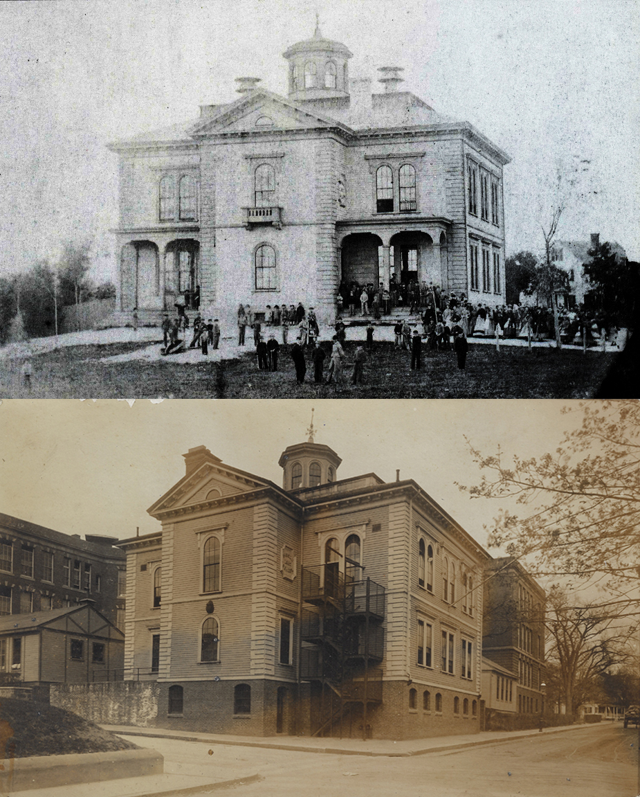
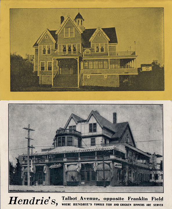
Dorchester Illustration 2526 Daloz Drycleaning

Daloz Cleansers started in Boston in the late 19th century.  It had retail shops in Boston although the actual work facility was located elsewhere, first in Roxbury, then South Boston,  then in 1900 in Dorchester at 11 Humphreys Street.  The Dorchester building later became the Humphreys Street Studios.

Today’s illustration comes from The Dorchester Beacon newspaper, May 5, 1900.  In that issue, the paper did a couple of dozen puff pieces about various businesses in Dorchester.  The text of the article follows:

L. H. Daloz

Cleansing and Dyeing, 11 Humphrey Street, 510 Tremont Street and 24 Bromfield Street

One of the latest establishments to come to Dorchester for a permanent location is the large dyeing establishment of Mr. L. H. Daloz.  This gentleman has followed the business in Boston for almost a quarter of a century and has become one of the leading and most prominent men in his line of business in the city.  For over thirty years he has been engaged in the cleansing and dyeing trade and most of the time on a large scale.  He began business in 1869 in New York City, and in 1877 he moved to Boston, opening a down town office and establishing his works in Roxbury.  In four years his business had grown so as to require larger and better quarters, and in 1883 he moved his works to South Boston, locating on Dorchester Avenue and Rawson Street.  Here he remained for seventeen years, until recent changes and improvements there forced him to move.  He then turned to Dorchester and soon began the erection of a large plant at 11 Humphrey Street.  This he has but recently completed and is just getting fully established n his new quarters. He has a large frame and brick building 130 feet long and 40 feet wide, with three floors, giving him a total floor space over 15,000 square feet.  This larger building is completely equipped with all the machinery, apparatus and conveniences necessary for a thoroughly modern cleansing and dyeing plant, and Mr. Daloz is better prepared than ever to handle his large business.  He does cleansing an dying of all kinds and his methods are the most modern and improve, making it possible to treat the most delicate goods and colors successfully.  A specialty is made of fine garments, such as evening dresses, silk waists, fancy skirts, draperies, laces, etc.  The work is confined exclusively to cleansing and dyeing, and no laundry in connection with the establishment and no agents are employed.  The business is one directly with Mr. Daloz.  His many years’ experience makes it possible for him to give ladies the most valuable advice about the cleansing or dyeing of their wearing apparel or household goods, while his service in every branch of the business is the most expert and satisfactory.  At his Humphrey Street works, which are now in full operation, he employs thirty people.  He maintains two stores in the city, one at 510 Tremont Street another at 24 Bromfield Street.  Mr. Daloz has been a resident of Dorchester for the last fifteen years and has many friends in the district who esteem highly as a business man and citizen.

Posted in Uncategorized | Tagged , , , | Comments Off on Dorchester Illustration 2526 Daloz Drycleaning

Dorchester Illustration 2525 Lifeguard and Friends

Real photo post card: Lifeguard and friends at the beach.  The photograph is by A. W. Cutter of Dorchester, but we don’t have any information about him.

At the height of summer, it seems appropriate to show a vintage photo of people at the beach.  The style of the bathing suits indicate the photograph is from the early 20th century.

Posted in Uncategorized | Tagged , | Comments Off on Dorchester Illustration 2525 Lifeguard and Friends

Dorchester Illustration 2524 S. S. Pierce homestead

Samuel S. Pierce, the son of Daniel and Lydia Davenport Pierce, was born in the farmhouse owned by his family in what is now the Cedar Grove section of Dorchester.  The house appears to have been built in the 18th century, although there is no documentation to provide an exact date.  Samuel’s father was a cabinetmaker.   At an early age, Samuel worked for a firm of importers in Boston, then went into the grocery business for himself.  In 1831, he started his own grocery store, specializing in products for the well-to-do in Boston.  The firm of S. S. Pierce became widely known for catering to the cosmopolitan tastes of Boston residents and for introducing new foods to the market.

Pierce maintained a home on Union Park and the family homestead in Dorchester, both homes appearing in the Boston Directory.

Samuel married Ellen Maria Theresa Wallis in 1836, and they had eight children.  The family  lived in Boston during the winters and summered at the family house he owned in Dorchester. According to Anthony Sammarco, the house was enlarged after the Civil War to accommodate his family.  It stood on a knoll overlooking both Adams Village and and the Neponset River. The estate comprised a house and stable, with ten acres and marshland.  Samuel Stillman Pierce died in 1880, and his son Wallis Lincoln Pierce continued the trademark name and standards established by his father. The family included Samuel S. Pierce, Jr., who died as a young man in California, Dr. M. Vassar Pierce, a noted physician in Milton, and Holden White Pierce, who took over management of the Back Bay store of the S.S. Pierce Company.  They maintained their connection to Dorchester through their sister, Henrietta Pierce, who still summered in the family home.  By the time of World War I, the Pierce homestead was a rambling series of additions made over the years.

Henrietta M. Pierce died in 1920, and her heirs sold a portion of the property to the Archdiocese of Boston, and shortly thereafter St. Brendan’s Church was built facing the new Gallivan Boulevard. The remaining portion of the Pierce Estate was laid out as Lennoxdale, Myrtlebank, Rockne and Crockett Streets and St. Brendan’s Road in the late 1930s, allowing for the building of the many new houses.

Posted in Uncategorized | Tagged , , | Comments Off on Dorchester Illustration 2524 S. S. Pierce homestead

Dorchester Illustration 2523 Dorchester Historical Society report for the year

Although the Dorchester Historical Society had to close to visitors, the Society has been busy.  Please take a moment to review the summary of activities for the last year.

https://mcusercontent.com/2bf796f357150e4acf3f7e971/files/b36017a2-f94e-d228-016b-7cb739202a56/DHS_Annual_Review.pdf

We are continuing to monitor the spike in COVID infections, before we make the decision to open to visitors. Thank you.

Posted in Uncategorized | Tagged , , | Comments Off on Dorchester Illustration 2523 Dorchester Historical Society report for the year

Dorchester Illustration 2522 James Blake House

Dorchester Illustration 2522   James Blake House

The James Blake House at 735 Columbia Road is the oldest existing house in Boston.  It is 360 years old this summer.  We are sorry that the house is not open for public tours at this time.

The first illustration was drawn by John Goff to show the appearance of the house at the time it was built, based on the architectural evidence.  The second illustration appeared in The Memorial History of Boston in 1880. The appearance in 1880 was very much the same as today.  In the 18th century, the dormers were removed, and the windows were changed to make the house look more contemporary.

The analysis of tree rings in a representative sampling of the timbers in the framing has shown that the trees were felled in the winter of 1660-1661.  The house would have been built the following summer.

The house is one of a small number of post-Medieval timber-frame houses that survive in New England and one of only a few with West Country framing, that is, representative of the western English counties of Dorset, Devon, Cornwall, Somerset, Gloucestershire, Wiltshire and the City and County of  Bristol.  Most other buildings in Dorchester and in New England were built by housewrights from the south and east of England. (An example is the Pierce House on Oakton Avenue in Dorchester). West Country homes were known for using heavier timber in the framing, which is evident in the Blake House. 

The house was built on land that is approximately where the Eversource facility is located today on Massachusetts Avenue.  At the time the house was built, there was no roadway nearby.  When Massachusetts Avenue was created, the road ran right next to the Blake House property.

The original occupants of the house were James Blake and his wife Elizabeth Clap Blake. He was born in the area of England near Pitminster, in 1624, and emigrated with his parents to Dorchester in the 1630s. Deacon James Blake became a constable, town selectman, and deputy to the General Court. James and Elizabeth Clap (the daughter of Deacon Edward Clap and niece of Roger Clap) were married in 1651, and by the time they built the new home, they already had a growing family.

The first written reference appeared in the Dorchester Town Records in June 1669.  The Selectmen decided to build a house for the minister of the town and should be “such an house as James Blaks house is, namly 38 foote in lenth and 2- foote wid and 4 foote between Joynts gert worke.” In 1895, the City of Boston of Boston acquired the property to complete a large parcel for the building of municipal greenhouses. The Dorchester Historical Society, which had been incorporated in 1891 undertook the preservation of the Blake House as its first major project. The Society convinced the City to grant the Society the house and the right to move it to Richardson Park at its own expense. By January 1896, the house had been moved to its new location by a local building mover for $295. This seems to be the first recorded instance of a private residence being moved from its original site for the purpose of historic preservation.

Posted in Uncategorized | Tagged | Comments Off on Dorchester Illustration 2522 James Blake House

Dorchester Illustration 2521 Victory Road Bridge to Squantum

Dorchester Illustration 2521   Victory Road Bridge to Squantum

During World War I, a bridge was built from Commercial Point, Dorchester, to Squantum, Quincy, to allow workers to travel from Boston to the plant manufacturing destroyers at the Naval Air Station in Squantum.

Today we have a photo showing the bridge and a portion of a US Coast Survey chart of Boston Harbor from 1921 showing the location of the bridge across the opening of the Neponset River.  The view in the photograph is from the Quincy side toward Commercial Point with its coal gas holders.  The bridge first shows up in the Bromley Dorchester Atlas in 1918 and on the 1919 US Coast Survey chart, but by the 1927 Coast Survey it no longer appears.  We have not seen coast surveys between 1923 and 1927, so we don’t know the exact year it was taken down.  A comment found on the internet without documentation states it was taken down in 1925.

The following comes from Scientific American, May 4, 1918, p. 407

Building a Bridge in Six Weeks to Save a Half Hour

Nothing is too costly or impossible in carrying out our war program.  That is the impression one gets when travelling through any section of this big country during these days of preparation and toil for the struggle across the sea.

A typical case is that of the Squantum Destroyer Plant near Boston, Mass., which is popularly known as the Victory Plant in that locality.  One of the chief difficulties in locating the plant on the Quincy side of the Neponset River was the inaccessibility to Boston and the lost time and inconvenience of laborers and mechanics in getting to work.

Something had to be done–and done in a hurry.

So it was decided to run a bridge directly from the Squantum plant to the nearest point, which is known as Commercial Point, Dorchester.  As time was the paramount element, the type of construction decided upon was the usual wood pile construction, and as the bridge crosses a navigable river, a draw had to be installed which was, of course, of steel.  Work was started late in October, under the direction of Thomas C. Atwood, Supervising Engineer for the Bureau of Yards and Docks.  The bridge was completed shortly after the middle of December, so that by Christmas all laborers to and from the plan were furnished a direct route 20 minutes from the elevated terminal in Boston, thus doing away with approximately two and a half miles of distance to be traveled and one-half hour’s time for each trip; furthermore, and this is an important consideration where workmen are concerned, the extra carfare called for by the second street railway company has been eliminated.  Fortunately, the greater part of the work was completed before the ice reached sufficient thickness to cause trouble.

The Victory Bridge, as it is called, was first used for passenger traffic only in the rush hours morning and evening; but at the present time a half-hourly schedule is in effect continually through the day was well as extra service morning and evening.  Besides caring for street traffic, the bridge is used for pedestrians and for the teaming of materials to the Squantum works.

Note: A comment without documentation on the internet says: It opened on the 11th of January 1918. I ran across this when I stumbled on a request that a trolley line from Dudley Square be routed to the plant over the bridge.  Another comment on the internet says: There may, in fact, be a very small piece of this bridge left near the so-called Victory Park near the northbound Southeast Expressway off-ramp on Victory Road. You can see it when the vegetation clears in that area in the spring and fall. Anyway, there was a Boston Elevated trolley line over the Victory Bridge, which was a trestle structure made of wood with a steel draw span over the river’s navigable channel. The trolleys ran from the Dudley Street station into the shipyard via the Victory Bridge and Victory Road. The trip took 30 minutes and the fare was five cents.

Posted in Uncategorized | Tagged , , , , | Comments Off on Dorchester Illustration 2521 Victory Road Bridge to Squantum

Dorchester Illustration 2520 Thetford Avenue School

Today’s illustration shows a school building at the corner of Thetford Avenue and Evans Street.  The portrait photograph is a picture of Robert Swan.

The City built a primary school at the corner of Thetford Avenue and Evans Street between 1882 and 1884. The building does not appear in the atlas for 1882 but does in 1884.  The school was abandoned in1952, and it caught fire in 1954.  There is now a playground on the site.

Known for years as the Thetford Avenue School, the school was renamed in 1910 to become the Robert Swan School, in honor of the long-time master of the Winthrop School.  Robert Swan lived on Meeting House Hill and was master of the Winthrop School.

The following is from Special to The New York Times, June 3, 1902:

Boston, June 2.—Robert Swan, the oldest Principal of a Boston school, died at midnight at his home in Dorchester.  He attended as usual to the routine duties of his school throughout last week.   Shortly after 10 o’clock last evening he experienced difficulty in breathing,.  A physician was at once summoned, but Mr. Swan died within two hours.  He was born in Dorchester, Nov. 28, 1821.  He received his education in the local schools, and in 1837, before he had completed his studies, became an instructor.  He was promoted in September, 1856, to be master of the Winthrop School on Tremont Street.  Here he had remained since.

Posted in Uncategorized | Tagged , , | Comments Off on Dorchester Illustration 2520 Thetford Avenue School

Dorchester Illustration 2519 Collins Building

Dorchester Illustration 2519   Collins Building

The following is excerpted from the National Register description of the Collins Building, 213-217 Washington Street

In 1898, Charles F. Collins subdivided the land on either side of Kilton Street (now Norwell Street), between Washington Street and the railroad, and he decided to reserve the corner lot for a large mixed-use commercial building. In April 1898, Collins was granted a building permit for the construction of brick building, which was to contain stores, offices, and a function hall.

The Collins Building is typical of commercial buildings being constructed in urban centers at this time. It was not highly unusual to have a function hall in buildings of this type, particularly in town and neighborhood centers. Two examples of similar buildings are Palladio Hall and Hibernian Hall in Roxbury’s Dudley Square area (both NRIND), which both had retail space on the first floor, offices on the second, and a function hall above. It was an era when social clubs were abundant and sponsored greater numbers of public events, requiring large interior spaces. Many of the social clubs in urban centers were associated with particular ethnic groups, which had immigrated to this country in the late 19th and early 20th centuries, and established organizations that catered to customs brought from Europe.

Despite its Irish name, the early 20th century tenants of the Collins Building are representative of the large number of Jewish families who resided nearby at this time.

By 1900, Mt. Bowdoin had become a well developed middle-class neighborhood, with many fine single and multi-family dwellings. In 1910 about 300 Jewish families were living in the district that extends between Mt. Bowdoin and Franklin Park. In some sections of this district, the Jewish population was as high as 65%. Many of the earliest Jewish settlers in the neighborhood were members of the Beth El congregation, which met in a public hall on Washington Street near the railroad between the years 1908-1910. In 1910, the congregation, with a membership of about 60 families, began construction of a new synagogue on Fowler Street (two blocks west of the Collins Building). At the time, the Jewish Advocate reported, “the new synagogue, when erected, will be the first one in the Dorchester district.” The Boston City Directory of 1930 attests to the large number of Jewish families that had moved to the Washington Street/Bowdoin Avenue vicinity, an area previously dominated by the Irish.

When completed in 1898, the Collins Building held two stores at the first floor, several offices at the second floor, and a large function hall occupying most of the third floor. This division of space and use remained unchanged into the mid-20th century. The third floor was known as Bowdoin Hall until about 1910 when the name was changed to Mt. Bowdoin Hall. By 1918 the building was owned by Jacob Sidman who operated a grocery store there. Aside from Sidman, the earliest known occupants of the building include the Mt. Bowdoin Auto Repairing Company, operated by Mathew Freedman and Joseph Brenner of Chelsea. The Anthony Press, Great A & P Tea Company (grocery), Samuel Sidman shoes, and tailor Rubin Cohen were all tenants in 1930. By 1932 the function hall was known as the New Washington Auditorium. Jacob Sidman owned the building as late as 1933. By 1942 the hall was known as Silver Manor and was operated by Charles Rubin, a caterer with the company Louis Rubin & Sons. Rubin Cohen remained a tenant, along with the Oakes Ticket Company (printers); two other spaces were listed as “vacant” in city directories. By 1944 the property had been acquired by John Rubin. In 1953 the title passed from Robert Kelley to Helen S. Swartz. Her husband husband, Henry D. Swartz, had the legal occupancy changed toallow for light manufacturing and the assembly of plastic covers for pillows, mattresses, etc. The third floor hall has remained a large open space since its construction and over the years has served as a meeting place and function hall for local organizations and residents. In the 1960s the building was owned by Hyman Karlsberg. The property was eventually taken by the City of Boston in 1980 for nonpayment of taxes.

The Collins Building was passed on to the private sector as part of city efforts to encourage revitalization in the neighborhood in 1998. It was rehabilitated using federal investment tax credits to continue its mixed use character, including retail stores at the first floor and residential apartments above.

Posted in Uncategorized | Tagged , , , , | Comments Off on Dorchester Illustration 2519 Collins Building

Dorchester Illustration 2518 Norfolk Hall

Dorchester Illustration 2518   Norfolk Hall

Today’s illustration is from a program about Four Corners that the Dorchester Historical Society will present at 7 pm on June 27th.  To register for the virtual program on Zoom, go to www.dorchesterhistoricalsociety.org   The link for the program will be sent out a few days prior to the 27th.

Norfolk Hall was built in 1899-1895 to serve the International Order of the Odd Fellow (IOOF)’s local Norfolk Lodge, no. 48.  Located at 326 Washington Street at Four Corners, the building was designed with two stores on the street level with a banquet hall behind them.  The second floor was devoted to an assembly hall, and the third floor had a lodge room and a supper room. The building was designed by Boston architects West and Granger.  In 1937 there was a fire in the top floor, which was repaired.  The property was sold to a new owner and taken down in 1960.  It was replaced by a garage for 10 cars.  More recently a new mixed-use four-story building has been built, stretching from 324 to 336 Washington Street.  The permit for construction was granted in 2014.

Norfolk Hall fostered the creation of the Greenwood Memorial Church.

The first movement to found a Methodist Episcopal Church in the Mt. Bowdoin section of Dorchester was started in 1893, and by 1895 the group rented the New Norfolk Hall at 328 Washington Street, built the year before. It had an auditorium up one flight that could seat 420 people. Rev. Charles Tilton became pastor for both the Mt. Bowdoin Methodist Episcopal Church and the Boston Highlands Methodist Episcopal Church. These combined groups moved to their new church at the corner of Washington and Dakota Streets in 1901, now known as the Greenwood Memorial Church.

Posted in Uncategorized | Tagged , , | Comments Off on Dorchester Illustration 2518 Norfolk Hall

Dorchester Illustration 2517 Seymour Ice Cream

KONICA MINOLTA DIGITAL CAMERA

Time of year to think about ice cream, especially ice cream in Dorchester.  The Dorchester Ice Cream Company was founded by the Samuelian Brothers – Yeghia and his younger brother Michael – who changed his name to Seymour.  The 1916 original manufacturing plant was at 1051 and 1375 Dorchester Avenue, but the company relocated to 12 Ericsson Street in Port Norfolk in 1947. Yeghia’s sons, Albert and Malcolm Samuelian and Michael’s son Charles “Buddy” Seymour expanded the Seymours ice cream brand into supermarkets. The Samuelian family became sole owners in the 1970s, and a third generation of family members managed the business for another 30 years until it closed in 2001. The Seymours Ice Cream Company had the sole franchise in New England to manufacture the Nutty Buddy product from the Sweetheart Cup Company.  Their Dorchester ice cream company provided soda fountain display cards featuring his products, like the one pictured. 

The company was housed in the three-story brick building on Ericsson Street in Port Norfolk next to the building where the Boston Winery is now located. Just behind the brick building is the building with the monitor top that now houses the Boston Harbor Distillery.

All these buildings were part of the industrial complex at the northern end of Port Norfolk that was developed in the 1850s by the Putnam Horseshoe Nail Company, later taken over by the Lawley Shipyard, manufacturer of luxury sailboats and motor yachts.

Port Norfolk and the rest of the Neponset area of Dorchester saw an increase in development after the construction of the bridge at Granite Avenue in the 1830s. The bridge denied access to the Lower Mills landing by larger ships, and the port at Port Norfolk began to grow.  The introduction of the Old Colony Railroad in the 1840s encouraged further development.  Dorchester was part of Norfolk County prior to 1870 when it was annexed to the city of Boston, and the name of Port Norfolk came to be used for this area that was now a major port in Norfolk County.  Until 1870, it was a port town for Norfolk County.  In addition to Putnam Nail at the northern of the peninsula, the Port saw the introduction of the Stearns Lumber Yard at the southern and easterly sides of the peninsula and the Frost Coal Company next to the railroad bridge that crossed the river to Quincy.

Note from Paul Samuelian:

THE SEYMOUR ICE CREAM STORY

I am Paul Samuelian one of the last owners of Seymours Ice Cream.

It was started in the 1930’s with my grandfather Yeghia Samuelian, and his brother Michael Samuelian (Uncle Mike). Mike wanted a more American sounding name, so he changed it to Seymour.  They had a small general store and soda fountain on Dorchester Avenue, and they made their ice cream in the basement.  Eventually the property in Port Norfolk area at 12 Ericsson Street was purchased and moved to that location on or about 1947.  At that time there were four owners. Michael Seymour, his son Buddy, and Yeghia’s two sons, Albert and Malcolm Samuelian who took over when Yeghia died. 

When My father (Malcolm) died in 1959Albert took over for the Samuelian side of the family. Uncle Mike died on 1962 at which time Albert took over as President and Treasurer of the Corporation. Some where in the 1960’s the “Nutty Buddy” was born named after Buddy Seymour who was my Great Uncle Mike’s son.

Contrary to what is on the internet the Seymour family left the ice cream business in 1970 and it was carried on by Albert Y. Samuelian, his three children, Joseph Carole and Dianne.  I was also there in 1970 representing my father Malcolm and my sister Vivian.  When Albert died in 1980, Seymours ice cream continued in which Dianne became President, Carole Treasurer and Paul and Joseph as Vice Presidents.

Seymours officially closed its doors in 2001 and the buildings were sold to the owners of Vinezia Restaurant.

Posted in Uncategorized | Tagged , , , , | Comments Off on Dorchester Illustration 2517 Seymour Ice Cream